


Como Voting District, Panola County, Mississippi
About
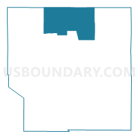
Outline

Summary
| Unique Area Identifier | 606400 |
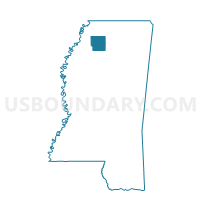
| Name | Como Voting District |
| County | Panola County |
| State | Mississippi |
| Area (square miles) | 66.90 |
| Land Area (square miles) | 66.75 |
| Water Area (square miles) | 0.15 |
| % of Land Area | 99.78 |
| % of Water Area | 0.22 |
| Latitude of the Internal Point | 34.50665600 |
| Longtitude of the Internal Point | -89.95894730 |
Maps

Graphs
Select a template below for downloading or customizing gragh for Como Voting District, Panola County, Mississippi


Neighbors
Neighoring Voting District (by Name) Neighboring Voting District on the Map
- East Sardis Voting District, Panola County, MS
- Longtown Voting District, Panola County, MS
- Looxahoma Voting District, Tate County, MS
- Pleasant Grove Voting District, Panola County, MS
- Pleasant Mount Voting District, Panola County, MS
- Senatobia No.1 Voting District, Tate County, MS
- Senatobia No.4 Voting District, Tate County, MS
- Sherrod Voting District, Tate County, MS
- West Sardis Voting District, Panola County, MS
Top 10 Neighboring County Subdivision (by Population) Neighboring County Subdivision on the Map
- District 1, Tate County, MS (7,213)
- District 2, Panola County, MS (6,873)
- District 1, Panola County, MS (6,331)
- District 4, Tate County, MS (5,206)
Top 10 Neighboring Place (by Population) Neighboring Place on the Map
Top 10 Neighboring Unified School District (by Population) Neighboring Unified School District on the Map
- Tate County School District, MS (19,143)
- North Panola School District, MS (11,412)
- Senatobia Municipal School District, MS (9,743)
Top 10 Neighboring State Legislative District Lower Chamber (by Population) Neighboring State Legislative District Lower Chamber on the Map
- State House District 8, MS (27,100)
- State House District 10, MS (25,832)
- State House District 11, MS (21,994)
- State House District 9, MS (20,516)
Top 10 Neighboring State Legislative District Upper Chamber (by Population) Neighboring State Legislative District Upper Chamber on the Map
Top 10 Neighboring 111th Congressional District (by Population) Neighboring 111th Congressional District on the Map
Top 10 Neighboring Census Tract (by Population) Neighboring Census Tract on the Map
- Census Tract 9501, Panola County, MS (7,446)
- Census Tract 9502, Tate County, MS (6,669)
- Census Tract 9503.02, Tate County, MS (6,069)
- Census Tract 9503, Panola County, MS (5,574)
- Census Tract 9502, Panola County, MS (2,687)